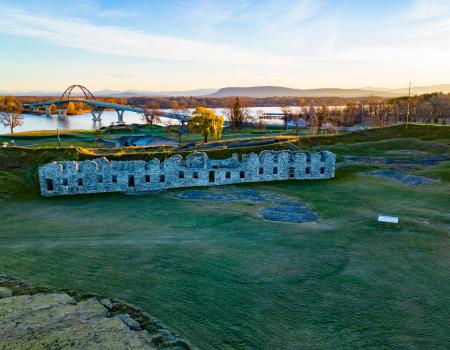
21 Grandview Drive, Crown Point | (518) 597-4666
The historic Crown Point is definitely a "don't miss" stop in the Lake Champlain Region! The grounds are free to explore, but there is an admission fee at museum.
Weddings
8ac44921-7798-4055-9c87-05d19eefb6c6
21 Grandview Drive, Crown Point | (518) 597-4666
The historic Crown Point is definitely a "don't miss" stop in the Lake Champlain Region! The grounds are free to explore, but there is an admission fee at museum.
History
8ac44921-7798-4055-9c87-05d19eefb6c6
21 Grandview Drive, Crown Point | (518) 597-4666
The historic Crown Point is definitely a "don't miss" stop in the Lake Champlain Region! The grounds are free to explore, but there is an admission fee at museum.
8ac44921-7798-4055-9c87-05d19eefb6c6
Route 22, Westport | (518) 962-2287
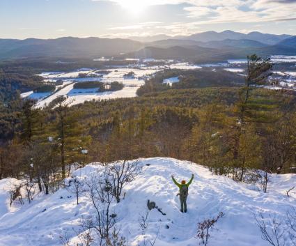
Explore the hidden quarry! This loop trail explores two delightful little forest areas and a field, with old cement structures from the turn of the previous century. Hidden Quarry Trailhead: There is a little grassy area for parking on the east side...
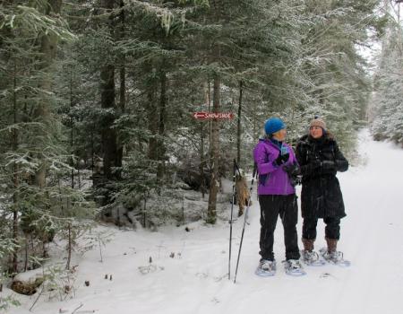
Snowshoeing
212e8b0e-5cf2-4e1d-89f9-4f666a6c5bb8
21 Grandview Drive, Crown Point | (518) 597-4666
The historic Crown Point is definitely a "don't miss" stop in the Lake Champlain Region! The grounds are free to explore, but there is an admission fee at museum.
Cross Country Skiing
8ac44921-7798-4055-9c87-05d19eefb6c6
21 Grandview Drive, Crown Point | (518) 597-4666
The historic Crown Point is definitely a "don't miss" stop in the Lake Champlain Region! The grounds are free to explore, but there is an admission fee at museum.
Weddings
8ac44921-7798-4055-9c87-05d19eefb6c6
21 Grandview Drive, Crown Point | (518) 597-4666
The historic Crown Point is definitely a "don't miss" stop in the Lake Champlain Region! The grounds are free to explore, but there is an admission fee at museum.
Hiking
8ac44921-7798-4055-9c87-05d19eefb6c6
21 Grandview Drive, Crown Point | (518) 597-4666
The historic Crown Point is definitely a "don't miss" stop in the Lake Champlain Region! The grounds are free to explore, but there is an admission fee at museum.
Snowshoeing
8ac44921-7798-4055-9c87-05d19eefb6c6
21 Grandview Drive, Crown Point | (518) 597-4666
The historic Crown Point is definitely a "don't miss" stop in the Lake Champlain Region! The grounds are free to explore, but there is an admission fee at museum.
History
8ac44921-7798-4055-9c87-05d19eefb6c6
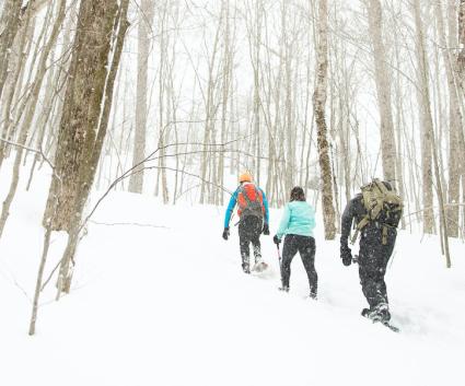
Sherman Road, Westport | (866) 843-5253
The Woods and Swale Trail gently goes up and down through an old forest, then it continues through a pine plantation, skirts the wet swale, and traverses the side of a hill to the north trailhead on Sherman Road. Return via the trail or road...
Snowshoeing
a9b4a867-742f-41ec-80d5-2ec3ea32c5fc
6475 U.S. 9, Elizabethtown
Owl Head Lookout is a true hidden gem, and should not be overlooked! In any season, but especially in fall, the views of the sweeping forest will absolutely take your breath away.
Hiking
d979f21e-eabd-4985-97f6-963f0d438e8f
Route 9, New Russia
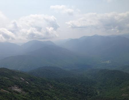
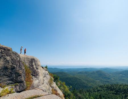
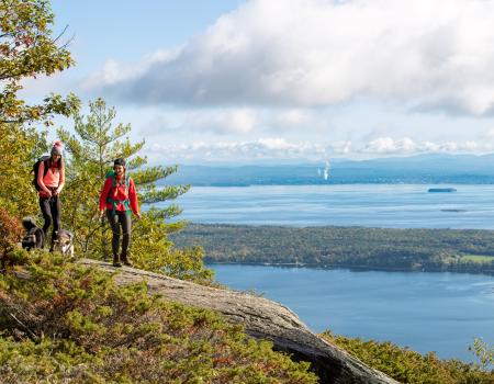
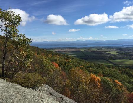
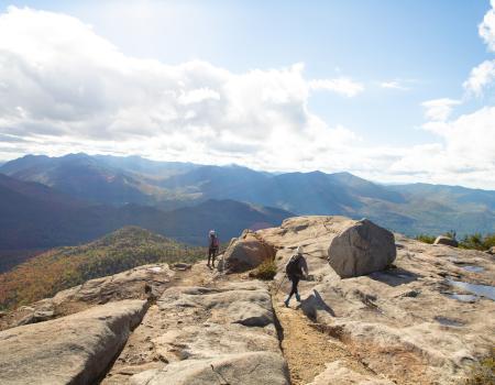
Hiking Rocky Peak Ridge is the 20th highest peak in the Adirondacks at 4,420 feet in elevation. It offers outstanding views from its summit, and is usually less-crowded than neighboring Giant.
Hiking
73ee7918-916d-4b57-a716-942e56669a79
Cook Rd/Walker Rd, Essex
The Beaver Flow Trail is a flat, easy snowshoe route that meanders through a mixed forest and runs parallel to a small waterway.
Snowshoeing
114ad94f-807e-44f8-b450-3d84bdc4c2d1
763 Putts Pond Road, Ticonderoga
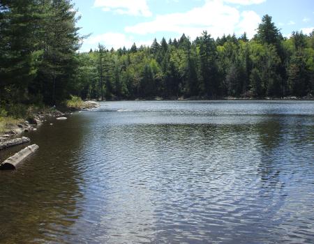
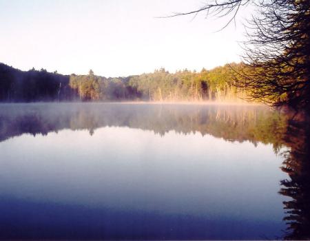
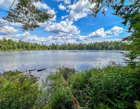
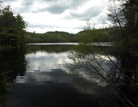
Crane Pond is a beautiful gem in the Pharaoh Lake Wilderness.
Paddling
b149c6a1-0f6c-4eef-a456-dda74d3b4c34
Route 9, Keeseville
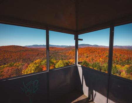
Poke-O-Moonshine Mountain has a commanding summit view which gets even better when the fire tower is open. There's 360 degree views of the High Peaks and Green Mountains in Vermont, Lake Champlain, and the Champlain Valley.
Snowshoeing
ba0c97ad-593d-4b70-a1f0-abe0e0dbfa30
763 Putts Pond Road, Ticonderoga
For a short but sweet walk in the wilderness, check out the Grizzle Ocean loop in the Pharaoh Lake Wilderness Area.
Snowshoeing
2b7db099-b476-4f0a-9fe8-5976a17b0da4
Route 9, New Russia
Hiking Rocky Peak Ridge is the 20th highest peak in the Adirondacks at 4,420 feet in elevation. It offers outstanding views from its summit, and is usually less-crowded than neighboring Giant.
Snowshoeing
73ee7918-916d-4b57-a716-942e56669a79
Trout Pond Road, Keeseville
Explore a wilderness preserve and hike a trail to a remote pond.
7db857ad-858f-4c7c-952e-e44c47246219
Bronson Way , Elizabethtown
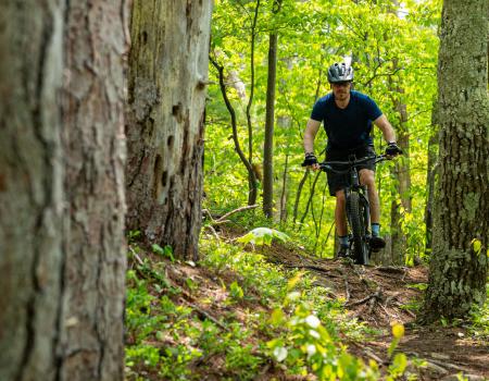
The Blueberry Hill Trails are located in the Town of Elizabethtown and were built for hiking, snowshoeing, mountain biking, horseback riding, and cross country skiing. There are several other viewing areas within the trail system that are quite rewarding.
Campgrounds
48d20e41-f049-4be8-8ce7-998b725b6009
Sherman Road, Westport | (866) 843-5253
Wonderful outing through an old forest and a pine plantation, then follows the border of the wetlands before traversing the side of a hill.
f5b2a355-904c-45d6-b733-83e2637d3216
Rt 22, Willsboro | (518) 585-6619
The Noblewood nature and birding trail is open year round. Off-season admission (by foot) is free.
eed7350b-04be-41c7-9ca3-7ffb680b0e4f
154-166 Soper Rd Giddings Road Trailhead, Keeseville
This is a great place for hiking, birding, cross- country skiing, and snowshoeing! There is also a wheelchair accessible trail.
Cross Country Skiing
cd58dc2a-9010-40b8-bf48-5656d0cc9f69
154-166 Soper Rd Giddings Road Trailhead, Keeseville
This is a great place for hiking, birding, cross- country skiing, and snowshoeing! There is also a wheelchair accessible trail.
Running
cd58dc2a-9010-40b8-bf48-5656d0cc9f69
Route 9, New Russia
Hiking Rocky Peak Ridge is the 20th highest peak in the Adirondacks at 4,420 feet in elevation. It offers outstanding views from its summit, and is usually less-crowded than neighboring Giant.
Campgrounds
73ee7918-916d-4b57-a716-942e56669a79
Stevenson Road, Westport
The Mountain Spring Road Trail is an easy, 8-mile-loop that follows a seasonal road through the Adirondack foothills, known as the West Champlain Hills, to Mineville.
Snowshoeing
3a9fa7bc-39aa-4d77-8688-5f0fec0c9846
4525 NYS Route 22 (across the road), Willsboro
This mountain is well-known for offering great "value for effort." There are spectacular views of the entire area from the top.
Hiking
3db74752-2464-4bef-a912-d0a177b7ad65
Ensign Pond Road, Moriah
A pleasant woods walk to Trout Pond, with a trail that follows half of the pond's shoreline. Trailhead: The Ensign Pond Road/Route 4 trailhead offers the easiest access. From the intersection of Route 9 and Route 4, go 6.2 miles northeast and look for...
Snowshoeing
3618e225-bd97-4819-af59-e2ca915e5f59
6475 U.S. 9, Elizabethtown
Owl Head Lookout is a true hidden gem, and should not be overlooked! In any season, but especially in fall, the views of the sweeping forest will absolutely take your breath away.
Snowshoeing
d979f21e-eabd-4985-97f6-963f0d438e8f
Library Street/Willsboro boat launch, Willsboro
This quiet path through the forests of Willsboro is perfect for an afternoon stroll in any season! Plus, it has a universal access loop that all can enjoy!
1c6985b8-2e54-4d86-a334-e04c10d91a28
763 Putts Pond Road, Ticonderoga
For a short but sweet walk in the wilderness, check out the Grizzle Ocean loop in the Pharaoh Lake Wilderness Area.
Campgrounds
2b7db099-b476-4f0a-9fe8-5976a17b0da4
Stevenson Road, Westport
The Mountain Spring Road Trail is an easy, 8-mile-loop that follows a seasonal road through the Adirondack foothills, known as the West Champlain Hills, to Mineville.
Hiking
3a9fa7bc-39aa-4d77-8688-5f0fec0c9846
Route 9, New Russia
This aptly-named mountain is the first summit on the East Trail to Rocky Peak and Giant at 1.9 miles from Rt. 9.
Snowshoeing
f4b4e0de-66ab-4e69-8e8d-6943d6a62680
Route 9, Keeseville
Poke-O-Moonshine Mountain has a commanding summit view which gets even better when the fire tower is open. There's 360 degree views of the High Peaks and Green Mountains in Vermont, Lake Champlain, and the Champlain Valley.
Hiking
ba0c97ad-593d-4b70-a1f0-abe0e0dbfa30
Bronson Way , Elizabethtown
The Blueberry Hill Trails are located in the Town of Elizabethtown and were built for hiking, snowshoeing, mountain biking, horseback riding, and cross country skiing. There are several other viewing areas within the trail system that are quite rewarding.
Cycling
48d20e41-f049-4be8-8ce7-998b725b6009
Bronson Way , Elizabethtown
The Blueberry Hill Trails are located in the Town of Elizabethtown and were built for hiking, snowshoeing, mountain biking, horseback riding, and cross country skiing. There are several other viewing areas within the trail system that are quite rewarding.
Running
48d20e41-f049-4be8-8ce7-998b725b6009
Lake Shore Road, Westport
The largest undeveloped tract of land on the Lake Champlain shoreline, Split Rock Wild Forest covers 3,700 acres in the towns of Essex and Westport. There was plenty of trails to explore in the area!
Cross Country Skiing
33e6aa61-00ef-4339-a2b9-535f1b6be191
Montcalm Street, Ticonderoga | (518) 585-6619
Bicentennial Park offers picnic areas, riverfront trails, ball fields, lighted walking paths, tennis courts and a small boat launch. Scenic boat cruises, seasonal accommodations, campsites, numerous beaches and picnic areas abound. In winter the park...
Snowshoeing
92c9b8d5-4fda-471a-b04c-6e74dc0428ae
Route 9, Keeseville
Poke-O-Moonshine Mountain has a commanding summit view which gets even better when the fire tower is open. There's 360 degree views of the High Peaks and Green Mountains in Vermont, Lake Champlain, and the Champlain Valley.
ba0c97ad-593d-4b70-a1f0-abe0e0dbfa30
763 Putts Pond Road, Ticonderoga
Crane Pond is a beautiful gem in the Pharaoh Lake Wilderness.
Fishing
b149c6a1-0f6c-4eef-a456-dda74d3b4c34
154-166 Soper Rd Giddings Road Trailhead, Keeseville
This is a great place for hiking, birding, cross- country skiing, and snowshoeing! There is also a wheelchair accessible trail.
Hiking
cd58dc2a-9010-40b8-bf48-5656d0cc9f69
4525 NYS Route 22 (across the road), Willsboro
This mountain is well-known for offering great "value for effort." There are spectacular views of the entire area from the top.
Snowshoeing
3db74752-2464-4bef-a912-d0a177b7ad65
Angier Hill Road, Westport | (518) 962-2287
This scenic, easy walk is perfect for anyone. Be advised there may be trail closures in the area around hunting season. Check the CATS website for the latest info.
aa5bf557-9048-4cba-8253-7cf7dd2e5dae
Sherman Road, Westport | (866) 843-5253
Wonderful outing through an old forest and a pine plantation, then follows the border of the wetlands before traversing the side of a hill.
f5b2a355-904c-45d6-b733-83e2637d3216
763 Putts Pond Road, Ticonderoga
Crane Pond is a beautiful gem in the Pharaoh Lake Wilderness.
Fishing
b149c6a1-0f6c-4eef-a456-dda74d3b4c34
154-166 Soper Rd Giddings Road Trailhead, Keeseville
This is a great place for hiking, birding, cross- country skiing, and snowshoeing! There is also a wheelchair accessible trail.
cd58dc2a-9010-40b8-bf48-5656d0cc9f69
Route 22, Westport
Explore the hidden quarry! This loop trail explores two delightful little forest areas and a field, with old cement structures from the turn of the previous century.
a5f60b08-80e5-4208-8418-a1ed1a57193d
Trout Pond Road, Keeseville
Explore a wilderness preserve and hike a trail to a remote pond.
7db857ad-858f-4c7c-952e-e44c47246219
763 Putts Pond Road, Ticonderoga
Crane Pond is a beautiful gem in the Pharaoh Lake Wilderness.
Cross Country Skiing
b149c6a1-0f6c-4eef-a456-dda74d3b4c34
Bicentennial Park, Ticonderoga
Take a lovely loop around Bicentennial Park in Ticonderoga with many interpretive signboards to learn about history and nature.
c40f50ba-e0a9-4243-8815-29dc25f86100
Route 22, Westport
Explore the hidden quarry! This loop trail explores two delightful little forest areas and a field, with old cement structures from the turn of the previous century.
a5f60b08-80e5-4208-8418-a1ed1a57193d
Route 9, Keeseville
Poke-O-Moonshine Mountain has a commanding summit view which gets even better when the fire tower is open. There's 360 degree views of the High Peaks and Green Mountains in Vermont, Lake Champlain, and the Champlain Valley.
ba0c97ad-593d-4b70-a1f0-abe0e0dbfa30
154-166 Soper Rd Giddings Road Trailhead, Keeseville
This is a great place for hiking, birding, cross- country skiing, and snowshoeing! There is also a wheelchair accessible trail.
cd58dc2a-9010-40b8-bf48-5656d0cc9f69
Brookfield Road, Essex
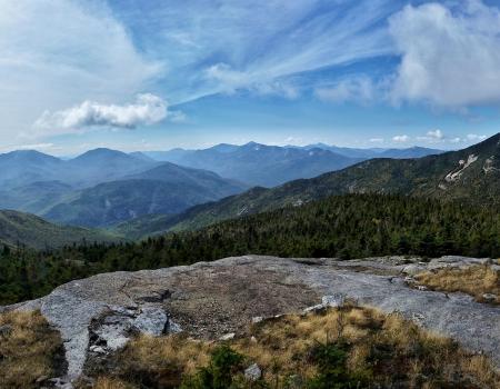
The Split Rock Wildway is a "wildlife corridor" between Lake Champlain and the Adirondack Mountains. A fairly easy climb rewards with incredible views of the valley and all its passages.
Hiking
60426e04-f96c-477e-b792-6d2bed8e5d23
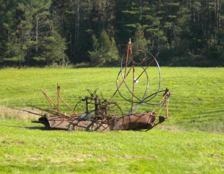
Sayre Rd POB 193, Westport | (518) 962-2287
Property owner and artist Ted Cornell has worked with Champlain Area Trails to create a hiking path which shows off some of his outdoor sculptures and artwork.
79cb226b-dd0d-4a51-9c37-0ef30b1630c0
Sherman Road, Westport | (866) 843-5253
Wonderful outing through an old forest and a pine plantation, then follows the border of the wetlands before traversing the side of a hill.
f5b2a355-904c-45d6-b733-83e2637d3216
Lake Shore Road, Westport
The largest undeveloped tract of land on the Lake Champlain shoreline, Split Rock Wild Forest covers 3,700 acres in the towns of Essex and Westport. There was plenty of trails to explore in the area!
33e6aa61-00ef-4339-a2b9-535f1b6be191
Trout Pond Road, Keeseville
Explore a wilderness preserve and hike a trail to a remote pond.
7db857ad-858f-4c7c-952e-e44c47246219
Bronson Way , Elizabethtown
The Blueberry Hill Trails are located in the Town of Elizabethtown and were built for hiking, snowshoeing, mountain biking, horseback riding, and cross country skiing. There are several other viewing areas within the trail system that are quite rewarding.
Cross Country Skiing
48d20e41-f049-4be8-8ce7-998b725b6009
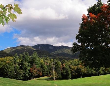
Route 9, Elizabethtown
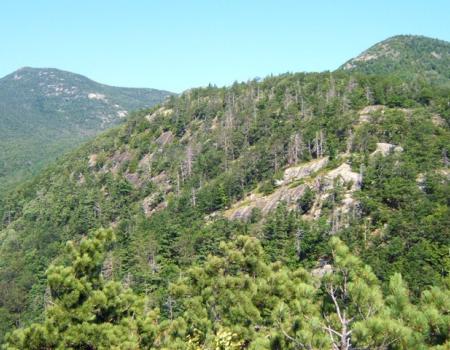
Giant is a shortened name for the peak that was originally called Giant of the Valley, and that's exactly what it is — a huge landmass that towers over Keene Valley and the surrounding lowlands.
Snowshoeing
54d39abe-36d6-4b9d-8504-8eaaa2cec46b
763 Putts Pond Road, Ticonderoga
Crane Pond is a beautiful gem in the Pharaoh Lake Wilderness.
Campgrounds
b149c6a1-0f6c-4eef-a456-dda74d3b4c34
624 Mountain View Drive , Willsboro
This is another fine trail in the CATS trail system.
Snowshoeing
f983575e-4cc4-4c8c-ab7a-0df63bc4d5c0
Sherman Road, Westport | (866) 843-5253
The Woods and Swale Trail gently goes up and down through an old forest, then it continues through a pine plantation, skirts the wet swale, and traverses the side of a hill to the north trailhead on Sherman Road. Return via the trail or road...
Cross Country Skiing
a9b4a867-742f-41ec-80d5-2ec3ea32c5fc
Route 9N, Keene
This is a wonderful open peak with a restored firetower that can be climbed, even though the tower is not needed for some of the best views in the High Peaks.
Snowshoeing
6ea9fda2-fc26-4741-93e2-dfa60ad4f5b5
Angier Hill Road, Westport | (518) 962-2287
This scenic, easy walk is perfect for anyone. Be advised there may be trail closures in the area around hunting season. Check the CATS website for the latest info.
Snowshoeing
aa5bf557-9048-4cba-8253-7cf7dd2e5dae
Montcalm Street, Ticonderoga | (518) 585-6619
Bicentennial Park offers picnic areas, riverfront trails, ball fields, lighted walking paths, tennis courts and a small boat launch. Scenic boat cruises, seasonal accommodations, campsites, numerous beaches and picnic areas abound. In winter the park...
Cross Country Skiing
92c9b8d5-4fda-471a-b04c-6e74dc0428ae
Cook Rd/Walker Rd, Essex
The Beaver Flow Trail is a flat, easy snowshoe route that meanders through a mixed forest and runs parallel to a small waterway.
114ad94f-807e-44f8-b450-3d84bdc4c2d1
Route 9, New Russia
Hiking Rocky Peak Ridge is the 20th highest peak in the Adirondacks at 4,420 feet in elevation. It offers outstanding views from its summit, and is usually less-crowded than neighboring Giant.
Hiking
73ee7918-916d-4b57-a716-942e56669a79
729 County Hwy 7C, Mineville
Known as the easiest fire tower in the Adirondacks, Belfry is excellent for any age or skill level. While this entire climb is uphill along an access road to the tower, it is very easy and has little elevation change.
Snowshoeing
d56786cd-951c-42b4-bacf-00d92c1af868
729 County Hwy 7C, Mineville
Known as the easiest fire tower in the Adirondacks, Belfry is excellent for any age or skill level. While this entire climb is uphill along an access road to the tower, it is very easy and has little elevation change.
d56786cd-951c-42b4-bacf-00d92c1af868
Ensign Pond Road, Moriah
A pleasant woods walk to Trout Pond, with a trail that follows half of the pond's shoreline. Trailhead: The Ensign Pond Road/Route 4 trailhead offers the easiest access. From the intersection of Route 9 and Route 4, go 6.2 miles northeast and look for...
Hiking
3618e225-bd97-4819-af59-e2ca915e5f59
Brookfield Road, Essex
The Split Rock Wildway is a "wildlife corridor" between Lake Champlain and the Adirondack Mountains. A fairly easy climb rewards with incredible views of the valley and all its passages.
Snowshoeing
60426e04-f96c-477e-b792-6d2bed8e5d23
Lake Shore Road, Westport
The largest undeveloped tract of land on the Lake Champlain shoreline, Split Rock Wild Forest covers 3,700 acres in the towns of Essex and Westport. There was plenty of trails to explore in the area!
Snowshoeing
33e6aa61-00ef-4339-a2b9-535f1b6be191
763 Putts Pond Road, Ticonderoga
Crane Pond is a beautiful gem in the Pharaoh Lake Wilderness.
Snowshoeing
b149c6a1-0f6c-4eef-a456-dda74d3b4c34
Sayre Rd POB 193, Westport | (518) 962-2287
Property owner and artist Ted Cornell has worked with Champlain Area Trails to create a hiking path which shows off some of his outdoor sculptures and artwork.
Cross Country Skiing
79cb226b-dd0d-4a51-9c37-0ef30b1630c0
Rt 22, Willsboro | (518) 585-6619
The Noblewood nature and birding trail is open year round. Off-season admission (by foot) is free.
Cross Country Skiing
eed7350b-04be-41c7-9ca3-7ffb680b0e4f
Lake Shore Rd, Westport
The trail climbs slightly from the trailhead and passes by a trail on the right that leads to Gary's Elbow. Continue straight ahead and take the next left at the top of the hill. The trail continues to climb moderately for just over a half mile to a...
Snowshoeing
f24a9460-7e96-4109-b84c-e1232d9e5041
Route 9, Elizabethtown
Giant is a shortened name for the peak that was originally called Giant of the Valley, and that's exactly what it is — a huge landmass that towers over Keene Valley and the surrounding lowlands.
Hiking
54d39abe-36d6-4b9d-8504-8eaaa2cec46b
Trout Pond Road, Keeseville
Explore a wilderness preserve and hike a trail to a remote pond.
7db857ad-858f-4c7c-952e-e44c47246219
Route 22, Westport
Explore the hidden quarry! This loop trail explores two delightful little forest areas and a field, with old cement structures from the turn of the previous century.
a5f60b08-80e5-4208-8418-a1ed1a57193d
729 County Hwy 7C, Mineville
Known as the easiest fire tower in the Adirondacks, Belfry is excellent for any age or skill level. While this entire climb is uphill along an access road to the tower, it is very easy and has little elevation change.
Hiking
d56786cd-951c-42b4-bacf-00d92c1af868
Route 9, Elizabethtown
Giant is a shortened name for the peak that was originally called Giant of the Valley, and that's exactly what it is — a huge landmass that towers over Keene Valley and the surrounding lowlands.
Hiking
54d39abe-36d6-4b9d-8504-8eaaa2cec46b
Bicentennial Park, Ticonderoga
Take a lovely loop around Bicentennial Park in Ticonderoga with many interpretive signboards to learn about history and nature.
Snowshoeing
c40f50ba-e0a9-4243-8815-29dc25f86100
Bicentennial Park, Ticonderoga
Take a lovely loop around Bicentennial Park in Ticonderoga with many interpretive signboards to learn about history and nature.
c40f50ba-e0a9-4243-8815-29dc25f86100
763 Putts Pond Road, Ticonderoga
Crane Pond is a beautiful gem in the Pharaoh Lake Wilderness.
Hiking
b149c6a1-0f6c-4eef-a456-dda74d3b4c34
154-166 Soper Rd Giddings Road Trailhead, Keeseville
This is a great place for hiking, birding, cross- country skiing, and snowshoeing! There is also a wheelchair accessible trail.
Snowshoeing
cd58dc2a-9010-40b8-bf48-5656d0cc9f69
Bronson Way , Elizabethtown
The Blueberry Hill Trails are located in the Town of Elizabethtown and were built for hiking, snowshoeing, mountain biking, horseback riding, and cross country skiing. There are several other viewing areas within the trail system that are quite rewarding.
Hiking
48d20e41-f049-4be8-8ce7-998b725b6009
Bicentennial Park, Ticonderoga
Take a lovely loop around Bicentennial Park in Ticonderoga with many interpretive signboards to learn about history and nature.
History
c40f50ba-e0a9-4243-8815-29dc25f86100
Lake Shore Rd, Westport
The trail climbs slightly from the trailhead and passes by a trail on the right that leads to Gary's Elbow. Continue straight ahead and take the next left at the top of the hill. The trail continues to climb moderately for just over a half mile to a...
Hiking
f24a9460-7e96-4109-b84c-e1232d9e5041
Route 9, New Russia
This aptly-named mountain is the first summit on the East Trail to Rocky Peak and Giant at 1.9 miles from Rt. 9.
Hiking
f4b4e0de-66ab-4e69-8e8d-6943d6a62680
Library Street/Willsboro boat launch, Willsboro
This quiet path through the forests of Willsboro is perfect for an afternoon stroll in any season! Plus, it has a universal access loop that all can enjoy!
1c6985b8-2e54-4d86-a334-e04c10d91a28
624 Mountain View Drive , Willsboro
This is another fine trail in the CATS trail system.
f983575e-4cc4-4c8c-ab7a-0df63bc4d5c0
Lake Shore Road, Westport
The largest undeveloped tract of land on the Lake Champlain shoreline, Split Rock Wild Forest covers 3,700 acres in the towns of Essex and Westport. There was plenty of trails to explore in the area!
Hiking
33e6aa61-00ef-4339-a2b9-535f1b6be191
Bronson Way , Elizabethtown
The Blueberry Hill Trails are located in the Town of Elizabethtown and were built for hiking, snowshoeing, mountain biking, horseback riding, and cross country skiing. There are several other viewing areas within the trail system that are quite rewarding.
Snowshoeing
48d20e41-f049-4be8-8ce7-998b725b6009
Route 9N, Keene
This is a wonderful open peak with a restored firetower that can be climbed, even though the tower is not needed for some of the best views in the High Peaks.
Hiking
6ea9fda2-fc26-4741-93e2-dfa60ad4f5b5
Montcalm Street, Ticonderoga | (518) 585-6619
Bicentennial Park offers picnic areas, riverfront trails, ball fields, lighted walking paths, tennis courts and a small boat launch. Scenic boat cruises, seasonal accommodations, campsites, numerous beaches and picnic areas abound. In winter the park...
92c9b8d5-4fda-471a-b04c-6e74dc0428ae
763 Putts Pond Road, Ticonderoga
For a short but sweet walk in the wilderness, check out the Grizzle Ocean loop in the Pharaoh Lake Wilderness Area.
Hiking
2b7db099-b476-4f0a-9fe8-5976a17b0da4
Stevenson Road, Westport
The Mountain Spring Road Trail is an easy, 8-mile-loop that follows a seasonal road through the Adirondack foothills, known as the West Champlain Hills, to Mineville.
Cycling
3a9fa7bc-39aa-4d77-8688-5f0fec0c9846
Walker Road/Sayre Road, Westport | (518) 962-2287
The easy trail trail goes through a meadow, winds through mixed forest, and ends at another meadow. It joins the Beaver Flow Trail at its northern trailhead.
Snowshoeing
d64feb70-ddff-4679-b090-ed5914c52061
Rt 22, Willsboro | (518) 585-6619
The Noblewood nature and birding trail is open year round. Off-season admission (by foot) is free.
Snowshoeing
eed7350b-04be-41c7-9ca3-7ffb680b0e4f
Sayre Rd POB 193, Westport | (518) 962-2287
Property owner and artist Ted Cornell has worked with Champlain Area Trails to create a hiking path which shows off some of his outdoor sculptures and artwork.
Snowshoeing
79cb226b-dd0d-4a51-9c37-0ef30b1630c0
Trout Pond Road, Keeseville
Explore a wilderness preserve and hike a trail to a remote pond.
7db857ad-858f-4c7c-952e-e44c47246219