
Wickham Marsh Wildlife Area
44.519603, -73.435369
This is a great place for hiking, birding, cross-country skiing, and snowshoeing. There is also a wheelchair accessible trail.
Hiking at Wickham Marsh
Carry a map and compass on this trail system, as it can be easy to get turned around. Hikers are reminded to stay on trails and to check for ticks after each visit.
As an overview, there are only two trails that have been adequately marked, while others lack disks. Deadfall has overtaken a few sections of trail, but the course through it is easy to follow. Be aware that hiking or running through some of the low lying trails may get you a bit on the wet and muddy side of things. The higher trails tend to stay along the peninsula and overlook the marsh. The ones that descend into the marsh tend to be a bit steep and can be a bit tough to hike or run up. The trails within the marsh have excellent varied terrain with rolling hills, wet conditions, some rocky footing and in a few cases a bit overgrown.
While most of the terrain is relatively flat, there are a few sections of decent elevation change. The Giddings Road trailhead starts out on a flat before descending steeply into the marsh. You also have the option to stay high and run on the flats a bit longer as well. If you do decide to drop into the marsh, you will have to battle a trail that is in a bit of disrepair for a bit to reach more adequate trails.
The Route 373 trailhead starts a bit higher than the marsh as well. This trailhead gives the runner a couple of nice options for loops without much elevation change. One trail that follows the state boundary is very steep with a quick down over a stream and then a steep up back to higher ground. Some of the trails follow old woods roads while others have been newly developed where the tread is limited. If you do decide to run the boundary line, it can be a bit difficult to follow in areas, so some extra time is needed to navigate. A beaver flow area also hides the property line.
To start in the marsh, begin at the Lake Champlain side and run to the marsh, then access the above trails from a lower elevation.
Birding
Wickham Marsh comprises over 860 acres of forest and marshland. In winter, birders can park in the parking area and walk up the berm to the railroad tracks to scan the lake for ducks.
The marsh and its trails are best in the warmer months for Virginia rail, common yellowthroat, breeding ducks such as blue-winged teal, and a variety of woodland birds. Birders who venture there in the evening may also be able to find eastern screech owls.
Hunting
Wickham Marsh Wildlife Management Area is open for hunting in season. Trails provide access to marsh and grassland areas.
Wickham Marsh in the winter
This area is excellent for snowshoeing and cross-country skiing, Keep in mind though, that for skiing, some of these trails are very steep. Snow pack in some of the areas a bit lacking in a not-so-good snow year, making the forests of evergreens less covered that the hardwood forests.
Accessibility
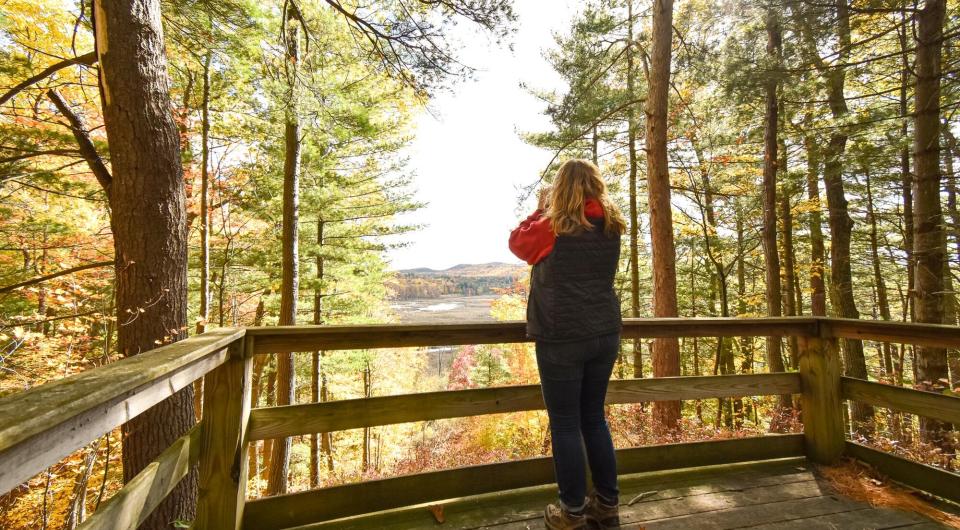
Wickham Marsh Wildlife Management Area features a wheelchair accessible trail and observation platform. A kiosk is located along the trail and one designated parking spot is reserved for people with disabilities. The parking area is located off Giddings Road (Back Road). A 300 foot long accessible trail brings users from the parking area to the viewing platform. A Bird Conservation Area kiosk is located halfway between the parking area and the platform.
The observation platform sits 200 feet above the marsh on the top of a steep ridge providing a 180 degree view of the marsh. Hundreds of acres of marsh and forest including two rare ecological communities can be seen from the platform. A northern white cedar swamp is located at the base of the ridge and a rich shrub fen is located just between the swamp and the mix of open water and cattail marsh. About 7 acres of grasslands can be seen on the opposite side of the marsh, and the osprey pole and nesting platform is located where the marsh meets the grassland.
Find more legendary trails in the Lake Champlain Region
Want to find more hikes in the Lake Champlain Region’s open spaces? With the Lake Champlain Region’s extensive trail network, there are endless options to choose from!
How to get there
There are three locations where you can access the trail system.
Route 373 Trailhead: From the intersection of Route 373 and Route 9 north of Keeseville, follow Route 373 for 1.4 miles to the trailhead on the left.
Lake Street Trailhead: From the intersection of Route 373 and Route 9 north of Keeseville, follow Route 373 for 3.0 miles to the Lake Street on the left. Follow Lake Street for 1.1 miles to the trailhead on the left.
Giddings Road Trailhead: From the intersection of Route 373 and Route 9 north of Keeseville, follow Route 373 for 3.0 miles to the Lake Street on the left. Follow Lake Street for 1.7 miles to Giddings Road on the left. Follow Giddings Road for about 0.75 miles to the trailhead on the left.


Keep Exploring


Packages and Promotions
recurring
Valid
Valid Feb. 18 - Apr. 2
weekly on Friday until April 3, 2026
Hot Turkey Sandwich Special
Pleasant Valley Café
Pleasant Valley Café
Make Fridays something to look forward to at Pleasant Valley Cafe with their Hot Open-Faced Turkey Sandwich special.
promotion
1
week
FR
FR
range
Valid Mar. 1 - Mar. 4
Valid Mar. 1 - Mar. 4
Family Deal at Boyea's
Family Deal at Boyea's
Boyea’s Grocery and Deli in Moriah is serving up a Family Deal you won’t want to miss
promotion
range
Valid Feb. 24 - Feb. 27
Valid Feb. 22 - Feb. 27
20¢ Off per Gallon of Gasoline
Avery Energy LLC
Avery Energy LLC
Save on Gas!
promotion
range
Valid Feb. 7
Valid Feb. 1 - Feb. 7
Super Bowl Feast at K&D Deli
K&D Deli
K&D Deli
Super Bowl Feast
K&D Deli and Grocery are hosting a watching party for the game!
promotion
range
Valid Oct. 21 - Apr. 30
Valid Oct. 21 - Apr. 30
Exclusive Indoor Pickleball at The Essex Inn
Essex Inn & Restaurant
Essex Inn & Restaurant
Two miles north of the Inn lies our newly-built, state-of-the art, private indoor pickleball court. “Our new court is the finest indoor pickleball
package
Other, Activities and Attractions
range
Valid Feb. 13
Valid Feb. 5 - Feb. 13
Olde Miners' Tavern Valentine's Day
Olde Miners' Tavern Valentine's Day
Celebrate Valentine’s Day with a special dinner made to impress.
promotion
range
Valid Jan. 25
Valid Jan. 19 - Jan. 25
Ti Mill Monday
Paper and Pencil
Paper and Pencil
Ti Mill Monday
Dinner, drinks and music with Dan Rabideau, Monday January 26 at The Paper and Pencil. Happy hour starts at 3:00 pm, music
promotion
range
Valid Feb. 7
Valid Feb. 4 - Feb. 7
Grover Hills Deli Super Bowl Specials
Grover Hills Deli
Grover Hills Deli
Super Bowl Specials
Hosting a crowd or keeping it simple?
promotion
range
Valid Feb. 13
Valid Feb. 8 - Feb. 13
Valentine's Day Specials at Suzie's
Suzie's
Suzie's
Valentine's Day Specials
promotion
range
Valid Feb. 13
Valid Feb. 5 - Feb. 13
Valentine's at Piper and Pine
Piper & Pine Florals Valentine's Day Specials
Thoughtfully designed blooms for Valentine’s Day
promotion
range
Valid Feb. 7
Valid Feb. 3 - Feb. 7
Willsboro Diner's Super Bowl Specials
Willsboro Diner
Willsboro Diner
promotion
range
Valid Mar. 15
Valid Mar. 3 - Mar. 15
St. Patrick's Day Bash
Paper and Pencil
Paper and Pencil
Celebrate St. Patrick's Day
Celebrate St.
promotion
range
Valid Nov. 30 - Jan. 3
Valid Nov. 24 - Jan. 3
Sail Champlain in 2026
Sail Adirondacks LLC
Sail Adirondacks LLC
Set Sail on a Lake Champlain Adventure in 2026!
Dreaming of a unique Lake Champlain experience?
promotion
Valid
Valid Jan. 29 - Feb. 13
Valentine's Date Night Dinner
Paper and Pencil
Paper and Pencil
promotion
range
Valid Feb. 13
Valid Feb. 1 - Feb. 13
Burleigh's Luncheonette Valentine's Dinner
Burleigh's Luncheonette
Burleigh's Luncheonette
Valentine's Dinner
Looking for a place to take your sweetheart? Check out our Valentine's Day dinner specials!
promotion
range
Valid Mar. 13
Valid Feb. 23 - Mar. 13
St. Patrick's Day Karaoke Night
Karaoke Night
Celebrate St.
promotion
range
Valid Feb. 11
Valid Jan. 11 - Feb. 11
Galentine's Day Sip and Shop
Vintage Reimagined
Vintage Reimagined
Vintage Reimagined invites you to join them as they reopen for the first night in 2026; Thursday, February 12 from 5:00-7:00 pm.
promotion
range
Valid Mar. 11 - Apr. 2
Valid Mar. 15 - Apr. 2
Boyea's March Madness Specials
March Madness Specials
Celebrate tournament season with March Madness Specials at Boyea’s Grocery & Deli
promotion
range
Valid Feb. 12 - Feb. 13
Valid Feb. 12 - Feb. 13
Valentine's Day special at Essex Ice Cream Cafe
Essex Ice Cream Cafe
Essex Ice Cream Cafe
Enjoy this special all week long
For $20 you can get:
promotion
range
Valid Mar. 14
Valid Mar. 2 - Mar. 14
St. Patrick's Dinner at Adirondack Eagles #4410
promotion
range
Valid Mar. 13
Valid Mar. 8 - Mar. 13
Burleigh's Luncheonette Shades of Green Special
Burleigh's Luncheonette
Burleigh's Luncheonette
Shades of Green Special
Celebrate the flavors of St.
promotion
range
Valid Feb. 7
Valid Feb. 3 - Feb. 7
Super Bowl Sunday Specials at Suzie's
Suzie's
Suzie's
Super Bowl Sunday Specials at Suzie’s
Game day calls for big flavor, and Su
promotion
range
Valid Feb. 13
Valid Feb. 2 - Feb. 13
Valentine's Night at the Pleasant Valley Cafe
Pleasant Valley Café
Pleasant Valley Café
Celebrate Valentine’s Night at The Pleasant Valley Café
Treat your special
promotion
range
Valid Feb. 13
Valid Feb. 5 - Feb. 13
Valentine's Day at Mountain Dog Restaurant and Pub
Mountain Dog Restaurant & Pub
Mountain Dog Restaurant & Pub
Valentine's Day Special Menu
The event takes place on February 14th from 4:00 pm – 8
promotion
range
Valid Feb. 7
Valid Feb. 3 - Feb. 7
Super Bowl Specials at Taco Temptation
SUPER BOWL SPECIALS at Taco Temptation!
promotion
range
Valid Feb. 23 - Feb. 28
Valid Feb. 23 - Feb. 28
Weekly Specials at Old Miners Tavern
Old Miners Tavern
Old Miners Tavern
Specials
The Old Miners Tavern is serving up comforting favorites in this week’s specials, available Tuesday
promotion