
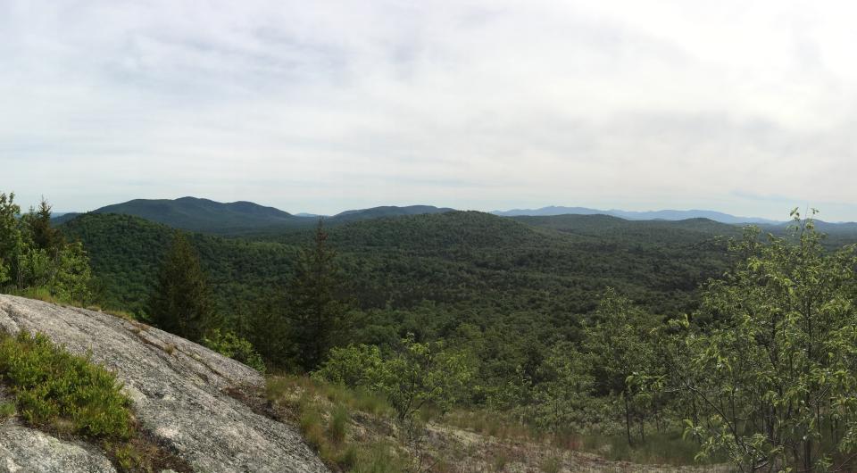
Bald Peak
44.150681, -73.631744
Bald Peak is commonly climbed when people hike to Rocky Peak Ridge via New Russia, but as a standalone hike is very worthwhile.
Key takeaways
- Distance: 6.7 miles round trip
- Elevation: 3060 feet
- Elevation gain: 2,720 feet
- Hike includes trail junctions and an exposed summit
Hiking Bald Peak
From the trailhead you will start climbing rather quickly and steadily to the first view on the left at 1.6 miles. A second view is on the right at 1.8 miles, and then after 2 miles you will have the option to either continue over aptly-named Blueberry Cobbles or take a short-cut to the right.
After the two trails rejoin, you start a climb over Mason Mountain, with nice views on a various ledges. After a short descent, you begin a steady, steep climb over many more ledges to the summit of Bald Peak. The trail continues to the summit of Rocky Peak Ridge.
Find more legendary trails in the Lake Champlain Region
Does Bald Peak sound amazing, but a little more than you want to tackle right now? With the Lake Champlain Region’s extensive trail network, we can easily help you find a hike that fits!
How to get there
Leave Lake Placid on Route 73, follow Route 73 toward Keene. Drive through Keene, Keene Valley and Saint Huberts. Take a left onto Route 9 toward Elizabethtown. Continue for 5 miles to the trailhead on the left.


Packages and Promotions
range
Valid Feb. 7
Valid Feb. 1 - Feb. 7
Super Bowl Feast at K&D Deli
K&D Deli
K&D Deli
Super Bowl Feast
K&D Deli and Grocery are hosting a watching party for the game!
promotion
range
Valid Feb. 13
Valid Feb. 8 - Feb. 13
Valentine's Day Specials at Suzie's
Suzie's
Suzie's
Valentine's Day Specials
promotion
range
Valid Mar. 11 - Apr. 2
Valid Mar. 15 - Apr. 2
Boyea's March Madness Specials
March Madness Specials
Celebrate tournament season with March Madness Specials at Boyea’s Grocery & Deli
promotion
range
Valid Feb. 24 - Feb. 27
Valid Feb. 22 - Feb. 27
20¢ Off per Gallon of Gasoline
Avery Energy LLC
Avery Energy LLC
Save on Gas!
promotion
range
Valid Feb. 13
Valid Feb. 10 - Feb. 13
Valentine's Dinner at The Deer's Head
The Deer's Head Inn
The Deer's Head Inn
Valentine's Day at The Deer's Head Inn Restaurant
Celebrate Valentine’s Day a
promotion
range
Valid Feb. 7
Valid Feb. 3 - Feb. 7
Super Bowl Sunday Specials at Suzie's
Suzie's
Suzie's
Super Bowl Sunday Specials at Suzie’s
Game day calls for big flavor, and Su
promotion
range
Valid Feb. 13
Valid Feb. 5 - Feb. 13
Valentine's at Piper and Pine
Piper & Pine Florals Valentine's Day Specials
Thoughtfully designed blooms for Valentine’s Day
promotion
recurring
Valid
Valid Feb. 18 - Apr. 2
weekly on Friday until April 3, 2026
Hot Turkey Sandwich Special
Pleasant Valley Café
Pleasant Valley Café
Make Fridays something to look forward to at Pleasant Valley Cafe with their Hot Open-Faced Turkey Sandwich special.
promotion
1
week
FR
FR
range
Valid Oct. 21 - Apr. 30
Valid Oct. 21 - Apr. 30
Exclusive Indoor Pickleball at The Essex Inn
Essex Inn & Restaurant
Essex Inn & Restaurant
Two miles north of the Inn lies our newly-built, state-of-the art, private indoor pickleball court. “Our new court is the finest indoor pickleball
package
Other, Activities and Attractions
range
Valid Feb. 13
Valid Feb. 1 - Feb. 13
Burleigh's Luncheonette Valentine's Dinner
Burleigh's Luncheonette
Burleigh's Luncheonette
Valentine's Dinner
Looking for a place to take your sweetheart? Check out our Valentine's Day dinner specials!
promotion
range
Valid Mar. 1 - Mar. 4
Valid Mar. 1 - Mar. 4
Family Deal at Boyea's
Family Deal at Boyea's
Boyea’s Grocery and Deli in Moriah is serving up a Family Deal you won’t want to miss
promotion
range
Valid Feb. 13
Valid Feb. 5 - Feb. 13
Valentine's Day at Mountain Dog Restaurant and Pub
Mountain Dog Restaurant & Pub
Mountain Dog Restaurant & Pub
Valentine's Day Special Menu
The event takes place on February 14th from 4:00 pm – 8
promotion
range
Valid Feb. 7
Valid Feb. 3 - Feb. 7
Super Bowl Specials at Taco Temptation
SUPER BOWL SPECIALS at Taco Temptation!
promotion
range
Valid Mar. 13
Valid Feb. 23 - Mar. 13
St. Patrick's Day Karaoke Night
Karaoke Night
Celebrate St.
promotion
range
Valid Mar. 13
Valid Mar. 8 - Mar. 13
Burleigh's Luncheonette Shades of Green Special
Burleigh's Luncheonette
Burleigh's Luncheonette
Shades of Green Special
Celebrate the flavors of St.
promotion
range
Valid Feb. 12 - Feb. 13
Valid Feb. 12 - Feb. 13
Valentine's Day special at Essex Ice Cream Cafe
Essex Ice Cream Cafe
Essex Ice Cream Cafe
Enjoy this special all week long
For $20 you can get:
promotion
range
Valid Jan. 25
Valid Jan. 19 - Jan. 25
Ti Mill Monday
Paper and Pencil
Paper and Pencil
Ti Mill Monday
Dinner, drinks and music with Dan Rabideau, Monday January 26 at The Paper and Pencil. Happy hour starts at 3:00 pm, music
promotion
range
Valid Feb. 7
Valid Feb. 3 - Feb. 7
Willsboro Diner's Super Bowl Specials
Willsboro Diner
Willsboro Diner
promotion
range
Valid Feb. 13
Valid Feb. 5 - Feb. 13
Olde Miners' Tavern Valentine's Day
Olde Miners' Tavern Valentine's Day
Celebrate Valentine’s Day with a special dinner made to impress.
promotion
range
Valid Nov. 30 - Jan. 3
Valid Nov. 24 - Jan. 3
Sail Champlain in 2026
Sail Adirondacks LLC
Sail Adirondacks LLC
Set Sail on a Lake Champlain Adventure in 2026!
Dreaming of a unique Lake Champlain experience?
promotion
range
Valid Feb. 23 - Feb. 28
Valid Feb. 23 - Feb. 28
Weekly Specials at Old Miners Tavern
Old Miners Tavern
Old Miners Tavern
Specials
The Old Miners Tavern is serving up comforting favorites in this week’s specials, available Tuesday
promotion
range
Valid Feb. 7
Valid Feb. 4 - Feb. 7
Grover Hills Deli Super Bowl Specials
Grover Hills Deli
Grover Hills Deli
Super Bowl Specials
Hosting a crowd or keeping it simple?
promotion
range
Valid Mar. 15
Valid Mar. 3 - Mar. 15
St. Patrick's Day Bash
Paper and Pencil
Paper and Pencil
Celebrate St. Patrick's Day
Celebrate St.
promotion
range
Valid Feb. 13
Valid Feb. 2 - Feb. 13
Valentine's Night at the Pleasant Valley Cafe
Pleasant Valley Café
Pleasant Valley Café
Celebrate Valentine’s Night at The Pleasant Valley Café
Treat your special
promotion
range
Valid Feb. 7
Valid Feb. 1 - Feb. 7
Boyea's Super Bowl 2026 Specials
Boyea's Super Bowl 2026 Specials
Boyea's Grocery & Deli is offering 5 dining specials for Super Bowl Sunday.
promotion
range
Valid Mar. 14
Valid Mar. 2 - Mar. 14
St. Patrick's Dinner at Adirondack Eagles #4410
promotion