Who would think a former landfill site could be a hiking destination? Last Saturday I hiked Cheney Mountain from the lower parking area on the Pelfershire Road, about 1mile from NYS Rte 9N between Westport and Moriah. The leaves still hadn't opened so it was a bumper day for views.
Cheney has been described as being the shape of a bread loaf. You climb up one end and hike around on the top. On the way up you get views through the low oaks that grow on the sloping rocks around the edges. Cheney is one of the heights of land researched by Jerry Jenkins who has identified loads of special plants. Because of his work scientists consider hills like Cheney "where it's at" for biodiversity in the Adirondack Park.
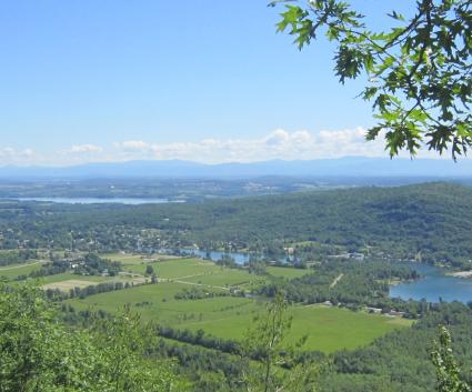
Recently trail signs have been added so it's easier to find the lookouts. There are three—all completely different. The north lookout features a view of Lake Champlain toward Split Rock Wild Forest. You can see the narrows where the lake is at its deepest (400 ft.) and also see Button Bay on the Vermont side.
As you walk toward the other end of the bread loaf there are a half dozen vernal pools. Last year they were nearly dry but this year we found lots of frog and salamander eggs. The wildflowers are getting started too with pretty purple and white hepaticas showing against last year's brown leaves.

The second view faces west over the remains of the iron mines that dominated the local community for decades. A huge slag pile and archaic buildings are the result of uncountable hours of labor by generations of local people. There are historic exhibit swith explanations and photos of the mines at the Iron Center Museum in the village of Port Henry. Iron from these mines was used to make the historic ironclad Monitor used by the Union Army in the Civil War.
The third overlook faces southeast. Center stage is the new Lake Champlain Bridge from the Crown Point Historic Site to Addison,Vermont.
The walk back down is easy. As we walked we noticed two or three species of butterflies coming to life after overwintering in the tree bark. At the trail register we swerved west to come out via the capped landfill. The grassy plateau had lots of wildlife sign and bird life—a pair of bluebirds and a pair of hairy woodpeckers were courting around the edge. The female bluebird perched and sang from one of the upright vents.

We had some extra time so added a bonus side-trip up the firetower on Belfry Mtn. It's a quick walk up a dirt road from the DEC marked trailhead on Dalton Road. There is a newly expanded firetower exhibit going up at the Adirondack History Museum in Elizabethtown this summer.
Looking down from Belfry the nearby villages looked peaceful. It was warm and we were thirsty so we went down for a round of Switchback at the King's Inn