
Penfield - Gravel Cycling - Intermediate
43.923013, -73.536243
Ride through history!
This fun and challenging ride begins at the birthplace of modern electricity.
How to get there
The ride begins in Ironville, in front of the Penfield Homestead Museum. The museum is located at the intersection of County Route 2 and Whitehead Road. (Coordinates: 43.922429, -73.5359160)
By the numbers
- Level of difficulty: Intermediate for out-and-back and Difficult for the loop route length: 19.2 miles (30.9 kilometers) for the out-and-back ride: 17.5 miles (28.2 kilometers)
- Elevation gain/loss: 1,107 feet (337 meters) for the out-and-back ride and 980 feet (299 meters) for the loop ride
- Road surface includes both smooth and broken pavement as well as both packed and loose gravel and dirt. The loop ride does contain several miles of rough dirt roads that include loose stones.
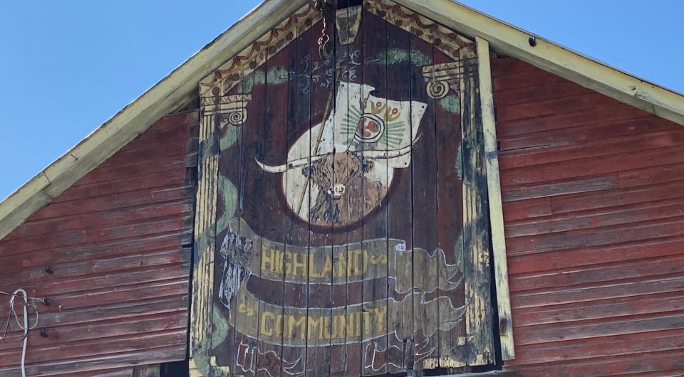
A hidden historical gem
Even for locals of the Adirondacks, Ironville is not well known, but the contributions made here to the modern electric age were as significant as any in the development of the industrial age. It was here in 1833 that the first industrial use of electricity occurred. The electro-magnet used in the Ironville forge was subsequently purchased by Thomas Davenport, an inventor from Vermont, who adapted the technology leading to the invention of the electric motor.
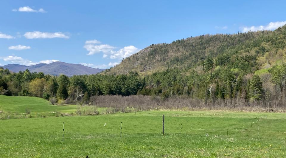
Country climbs
Leaving the picturesque and historic community of Ironville, you immediately head out on a quiet smooth country road that climbs gently. After a few twists and turns, you come upon an opening in the forest and a T-intersection. Turning left you quickly leave the open landscape behind, and for the rest of the ride you enter the land of gravel roads. You also enter the land of water. On this ride there seems to be a new stream or wetland around every turn. What’s great about all this water is that it attracts wildlife, so this ride provides opportunities to see wood ducks, beaver, muskrat, deer, great blue herons, and a host of other wonderful species that make the Adirondacks their home.
Once you reach Flemings Pond you can either return to your car following the Intermediate out-and-back route or if you have a fat tire bike AND a sense for adventure you can push on and ride a very rugged section of Stoney Lonesome Road following the Difficult RideWithGPS route.
Challenging pebbles ahead
What makes this difficult loop more adventurous is not the mileage or elevation, but the road surface. Simply put, it’s a sea of loose golf ball to baseball sized stones that makes riding technically difficult. But the reward for making the loop is that you get to have some excellent gravel fun, you get to see a truly impressive beaver dam, and you still get to have a fun downhill along a good gravel road and a bit of pavement down Stoney Lonesome Road. Once back to the car, take some time to enjoy the museum grounds and reflect on what a great ride you had.
Due to limited cellular coverage, please be sure to download this route and save for offline use before leaving home.

Packages and Promotions
range
Valid Feb. 23 - Feb. 28
Valid Feb. 23 - Feb. 28
Weekly Specials at Old Miners Tavern
Old Miners Tavern
Old Miners Tavern
Specials
The Old Miners Tavern is serving up comforting favorites in this week’s specials, available Tuesday
promotion
range
Valid Feb. 13
Valid Feb. 5 - Feb. 13
Olde Miners' Tavern Valentine's Day
Olde Miners' Tavern Valentine's Day
Celebrate Valentine’s Day with a special dinner made to impress.
promotion
range
Valid Feb. 13
Valid Feb. 5 - Feb. 13
Valentine's at Piper and Pine
Piper & Pine Florals Valentine's Day Specials
Thoughtfully designed blooms for Valentine’s Day
promotion
range
Valid Nov. 30 - Jan. 3
Valid Nov. 24 - Jan. 3
Sail Champlain in 2026
Sail Adirondacks LLC
Sail Adirondacks LLC
Set Sail on a Lake Champlain Adventure in 2026!
Dreaming of a unique Lake Champlain experience?
promotion
range
Valid Feb. 7
Valid Feb. 4 - Feb. 7
Grover Hills Deli Super Bowl Specials
Grover Hills Deli
Grover Hills Deli
Super Bowl Specials
Hosting a crowd or keeping it simple?
promotion
range
Valid Feb. 13
Valid Feb. 5 - Feb. 13
Valentine's Day at Mountain Dog Restaurant and Pub
Mountain Dog Restaurant & Pub
Mountain Dog Restaurant & Pub
Valentine's Day Special Menu
The event takes place on February 14th from 4:00 pm – 8
promotion
range
Valid Mar. 14
Valid Mar. 2 - Mar. 14
St. Patrick's Dinner at Adirondack Eagles #4410
promotion
range
Valid Feb. 13
Valid Feb. 10 - Feb. 13
Valentine's Dinner at The Deer's Head
The Deer's Head Inn
The Deer's Head Inn
Valentine's Day at The Deer's Head Inn Restaurant
Celebrate Valentine’s Day a
promotion
range
Valid Mar. 13
Valid Mar. 8 - Mar. 13
Burleigh's Luncheonette Shades of Green Special
Burleigh's Luncheonette
Burleigh's Luncheonette
Shades of Green Special
Celebrate the flavors of St.
promotion
range
Valid Apr. 14
Valid Apr. 13 - Apr. 14
Unhappy Hour
Mountain Dog Restaurant & Pub
Mountain Dog Restaurant & Pub
Unhappy Hour - Tax Day Therapy
Shake off Tax Day stress at Mountain Dog Restaurant and Pub’s “Unhappy Hour: Tax Day Therapy”!
promotion
range
Valid Feb. 7
Valid Feb. 3 - Feb. 7
Super Bowl Specials at Taco Temptation
SUPER BOWL SPECIALS at Taco Temptation!
promotion
range
Valid Feb. 11
Valid Jan. 11 - Feb. 11
Galentine's Day Sip and Shop
Vintage Reimagined
Vintage Reimagined
Vintage Reimagined invites you to join them as they reopen for the first night in 2026; Thursday, February 12 from 5:00-7:00 pm.
promotion
range
Valid Mar. 15
Valid Mar. 3 - Mar. 15
St. Patrick's Day Bash
Paper and Pencil
Paper and Pencil
Celebrate St. Patrick's Day
Celebrate St.
promotion
range
Valid Feb. 12 - Feb. 13
Valid Feb. 12 - Feb. 13
Valentine's Day special at Essex Ice Cream Cafe
Essex Ice Cream Cafe
Essex Ice Cream Cafe
Enjoy this special all week long
For $20 you can get:
promotion
range
Valid Feb. 7
Valid Feb. 3 - Feb. 7
Willsboro Diner's Super Bowl Specials
Willsboro Diner
Willsboro Diner
promotion
range
Valid Feb. 13
Valid Feb. 8 - Feb. 13
Valentine's Day Specials at Suzie's
Suzie's
Suzie's
Valentine's Day Specials
promotion
recurring
Valid
Valid Feb. 18 - Apr. 2
weekly on Friday until April 3, 2026
Hot Turkey Sandwich Special
Pleasant Valley Café
Pleasant Valley Café
Make Fridays something to look forward to at Pleasant Valley Cafe with their Hot Open-Faced Turkey Sandwich special.
promotion
1
week
FR
FR
range
Valid Jan. 25
Valid Jan. 19 - Jan. 25
Ti Mill Monday
Paper and Pencil
Paper and Pencil
Ti Mill Monday
Dinner, drinks and music with Dan Rabideau, Monday January 26 at The Paper and Pencil. Happy hour starts at 3:00 pm, music
promotion
range
Valid Feb. 7
Valid Feb. 1 - Feb. 7
Boyea's Super Bowl 2026 Specials
Boyea's Super Bowl 2026 Specials
Boyea's Grocery & Deli is offering 5 dining specials for Super Bowl Sunday.
promotion
range
Valid Jul. 1 - Jul. 4
Valid Jun. 30 - Jul. 4
Celebrate July 4th Week at the Old Dock
The Old Dock Restaurant (Seasonal)
The Old Dock Restaurant (Seasonal)
Celebrate the 4th with great food, live entertainment and stunning waterfront views.
promotion
range
Valid Feb. 24 - Feb. 27
Valid Feb. 22 - Feb. 27
20¢ Off per Gallon of Gasoline
Avery Energy LLC
Avery Energy LLC
Save on Gas!
promotion
Valid
Valid Jan. 29 - Feb. 13
Valentine's Date Night Dinner
Paper and Pencil
Paper and Pencil
promotion
range
Valid Feb. 7
Valid Feb. 3 - Feb. 7
Super Bowl Sunday Specials at Suzie's
Suzie's
Suzie's
Super Bowl Sunday Specials at Suzie’s
Game day calls for big flavor, and Su
promotion
range
Valid Feb. 7
Valid Feb. 1 - Feb. 7
Super Bowl Feast at K&D Deli
K&D Deli and Grocery
K&D Deli and Grocery
Super Bowl Feast
K&D Deli and Grocery are hosting a watching party for the game!
promotion
range
Valid Feb. 13
Valid Feb. 1 - Feb. 13
Burleigh's Luncheonette Valentine's Dinner
Burleigh's Luncheonette
Burleigh's Luncheonette
Valentine's Dinner
Looking for a place to take your sweetheart? Check out our Valentine's Day dinner specials!
promotion
range
Valid Mar. 13
Valid Feb. 23 - Mar. 13
St. Patrick's Day Karaoke Night
Karaoke Night
Celebrate St.
promotion
range
Valid Feb. 13
Valid Feb. 2 - Feb. 13
Valentine's Night at the Pleasant Valley Cafe
Pleasant Valley Café
Pleasant Valley Café
Celebrate Valentine’s Night at The Pleasant Valley Café
Treat your special
promotion
range
Valid Oct. 21 - Apr. 30
Valid Oct. 21 - Apr. 30
Exclusive Indoor Pickleball at The Essex Inn
Essex Inn & Restaurant
Essex Inn & Restaurant
Two miles north of the Inn lies our newly-built, state-of-the art, private indoor pickleball court. “Our new court is the finest indoor pickleball
package
Other, Activities and Attractions


