
Giant Mountain
44.138459, -73.743851
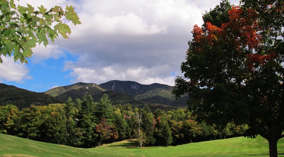
Giant is a shortened name for the peak that was originally called Giant of the Valley, and that's exactly what it is — a huge landmass that towers over Keene Valley and the surrounding lowlands. The parking areas for Giant Mountain often fill quickly, especially in the summer, and it is illegal to park along Route 73. Consider choosing a less popular, and less crowded, trail to avoid the risk of getting a ticket. Or just the approach from the north, which typically sees less traffic.
By the numbers
- Elevation: 4,627 feet
- Giant is High Peak #12
- Footpath distance and elevation gain depends on the trail taken. See descriptions below.
- Follow Leave No Trace principles
Hiking
There are three main routes up Giant with several variations possible, just be aware that all of them are steep, strenuous climbs beginner hikers. If you're not an experienced hiker, consider doing a less demanding mountain before attempting Giant.
In addition to the three trails described below, Giant can also be approached by first climbing Rocky Peak Ridge, another High Peak.
The North Trail
From Elizabethtown, head west on Route 9N for about 4.5 miles. The parking area is on the left.
- Elevation gain: 3,327 feet
- Distance: 7.4 miles, one way
Giant Mountain's North Trail leaves the parking area along a dirt driveway, which it follows for a short distance before dropping into the woods. From here it's an easy climb for the first mile to a crossing of Slide Brook, then it becomes a steady, but never steep, uphill walk. The trail rounds out atop a ridge at 2.5 miles, where there's a short, steep, 0.1 mile spur trail to Owl Head Lookout on the left. If you're already tired at this point, consider making the lookout your destination for the day — the trail up Giant will get more difficult.
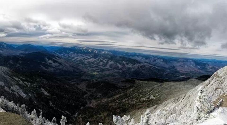
Continuing past the junction, the trail travels down into a valley before climbing to an open maple grove at 3.4 miles. Check out the view that's just past the grove on the left. The trail descends briefly then begins to climb more steeply to a large glacial bank called High Bank at 4.1 miles. The trail continues its long ascent of Giant, passing a lean-to at 5.7 miles before easing off a bit. Enjoy this easy stretch — the trail begins to steeply climb at 6.1 miles, it levels off again after 0.7 miles, then it again begins climbing to a nice ledge at 7.2 miles. From here the trail is pretty easy as it approaches the summit at 7.4 miles, where there are outstanding views of the Eastern High Peaks, including the Great Range.
Roaring Brook Trail
From Elizabethtown, take Route 9 south toward New Russia for just over 10 miles. Take a slight right onto Route 73 and continue for 5.5 miles to the trailhead on the right.
- Elevation gain: 3,375 feet
- Distance: 3.6 miles, one way
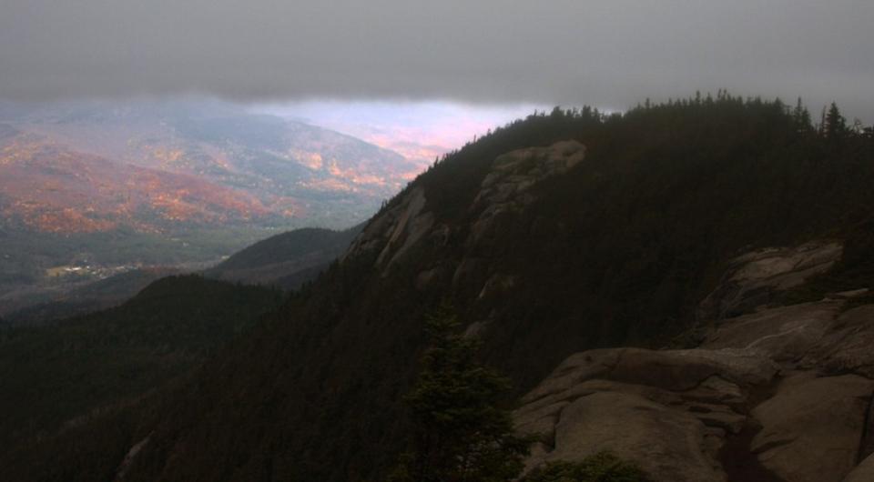
The Roaring Brook Trail begins deceptively easy as it proceeds on the level for 0.1 miles to the junction with the short and easy spur trail to the base of the 130-foot falls, which are well worth seeing. Bearing left, the trail ascends away from the valley at an even, moderate grade through a ruggedly beautiful forest. The path becomes pretty easy at 0.3 miles. At the half mile mark there is a trail to the right that leads to the top of Roaring Brook Falls. Take a minute to check out the view, just be aware that this is a dangerous place and it's best to avoid the edge of the falls, especially if the rocks are wet.
The path remains easy to moderate as it reaches a trail at 1.1 miles that connects to the Zander Scott Trail (see below) via Giant's Washbowl. The trail remains moderate until 1.4 miles, at which point it begins steeply climb away from Roaring Brook — there's even a wooden ladder at one point. The trail junction with the Zander Scott Trail is reached at 2.7 miles. From here, the trail alternates between moderate and steep grades, then it passes the trail to Rocky Peak Ridge 0.1 mile before reaching the summit.
Zander Scott Trail
From Elizabethtown, take Route 9 south toward New Russia for just over 10 miles. Take a slight right onto Route 73 and continue for 4 miles to the trailhead on the right.
- Elevation gain: 3,050 feet
- Distance: 3.2 miles, one way
This unrelentingly steep route up Giant begins climbing at the trailhead and never really eases until the summit. It is steep and exposed along a good portion of the ridge, which arguably makes it the most scenic approach to this peak.
The trail climbs moderately to steeply from the road with little reprieve to a nice lookout over Chapel Pond at 0.7 miles. Just beyond this is Giant's Washbowl, a pretty, rugged little mountain pond. The trail left connects to the Roaring Brook Trail, straight crosses the pond's outlet and passes a campsite before continuing up Giant. At the 1 mile mark there is a side trail left to Giant's Nubble. If you're already tired, consider making the 0.5 mile ascent to the Nubble and calling it a day — the Zander Scott trail becomes very steep after this junction.
Continuing on, the trail continues to climb and soon comes to the first open section of rock. Many other open sections follow as the path ascends Giant's long, mostly-exposed ridge. The climbing eases at 2.4 miles, where there's a junction with the Roaring Brook Trail. From here, the trail alternates between moderate and steep grades, then it passes the trail to Rocky Peak Ridge 0.1 mile before reaching the summit.
Camping
There is a primitive campsite near the outlet of Giant's Washbowl on the Zander Scott Trail, and a lean-to at the 5.7-mile mark on the North Trail.
Snowshoeing
Snowshoeing Giant Mountain in winter is a serious endeavor that should only be attempted after tackling a few of the area's smaller mountains. Snowshoes are required and will suffice on the generally well-packed trail, but snow spikes are highly recommended for the steep upper reaches of the mountain. The open stretches along the Zander Scott Trail are particularly hazardous when icy and should only be attempted by hikers with the proper gear and with experience on steep, open, icy routes. This is especially important on the descent.
Expect a significant drop in temperature as elevation is gained, and be prepared for strong winds on the open summit ledge. Always bring extra layers, especially for higher elevations, and don't hesitate to turn around if the weather starts to turn.

Packages and Promotions
range
Valid Apr. 3 - Apr. 8
Valid Feb. 21 - Apr. 7
Solar Eclipse Shirts
Small Town Boutique & Dolly & The Bean
Small Town Boutique & Dolly & The Bean
Solar Eclipse Shirts The Small Town Boutique will be offering some SE24 themed shirts for sale during the big event!
promotion
range
Valid Apr. 3 - Apr. 7
Valid Feb. 27 - Apr. 8
Montcalm Liquor Solar Eclipse Discount
10% discount on select items!
promotion
Dining Deals
range
Valid Feb. 4 - May. 4
Valid Feb. 21 - May. 4
Spring into a Free Night
Best Western Ticonderoga Inn & Suites
Best Western Ticonderoga Inn & Suites
Stay two nights, earn a free night.
package
Local Deals
range
Valid Feb. 25 - Feb. 25
Valid Feb. 25 - Nov. 29
Veterans, Military and Government Personnel Discounts
Best Western Ticonderoga Inn & Suites
Best Western Ticonderoga Inn & Suites
Discounts for Veterans, Military and Government Personnel Veterans, Military and Government Personnel enjoy discounts at or below per diem at Best Western(R) Hotels & Resorts throughout North America. Enter your desired destination and dates of travel...
package
Military Discounts
range
Valid Apr. 7
Valid Mar. 21 - Apr. 7
Ticonderoga Area SE24 Business Promotions & Specials
Ticonderoga Area Chamber of Commerce
Ticonderoga Area Chamber of Commerce
Ticonderoga Area Chamber of Commerce Business Promotions and Specials A wide variety of TACC businesses are offering specials and promotions for the Solar Eclipse to take place on Monday, April 8, 2024 including dining and shopping specials and discounts.
promotion
Eclipse ADK 2024, Dining Deals, Shopping Deals
range
Valid Apr. 3 - Apr. 7
Valid Feb. 21 - Apr. 7
SE24 Special Brew at Ledge Hill Brewing
Ledge Hill Brewing Co
Ledge Hill Brewing Co
promotion
range
Valid Apr. 4 - Apr. 7
Valid Mar. 19 - Apr. 7
Prime Eclipse Time Lodging
Park Motor Inn
Park Motor Inn
Enjoy any 3 nights in this beautiful little apartment between April 5th and April 8th. Prime Eclipse time. Call (518)873-2233 for details.
package
Local Deals
range
Valid Apr. 7
Valid Mar. 27 - Apr. 7
Total Eclipse Prix Fixe
The Deer's Head Inn
The Deer's Head Inn
The Deer's Head Inn is offering a special Prix Fixe for the Total Eclipse on April 8 for $60. To Start: Tuna and Swordfish Skewers or Black Trumpet Mushroom Toast Followed by: Squid Ink Pasta Then choose: Burnt Leek Ash Coated Pork Loin or Black Sea...
promotion
Eclipse ADK 2024, Dining Deals